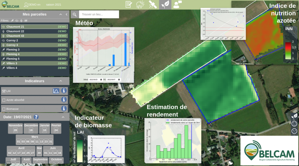
Launched officially in August 2019, the BELCAM platform offers free access to various products and services essentially from satellite imagery, with a view to improving the economic and environmental performance of farms. Its products and services independent from all commercial purposes have been developed by UCLouvain and the CRA-W in partnership with farmers and extension services (pilot and technical centres). They enable the farmer or breeder to monitor the growth and development of its winter wheat, corn, potato and pasture plots throughout the growth season and help them take decisions in particular relating to the management of nitrogen inputs and risk management. The products available include the prediction of the nitrogen balance and the development of the nitrogen status during the season, the changes in foliar development (through the LAI) and the possibility in this way of comparing the growth of a plot in comparison to its neighbours or an estimate of the final yield. The platform also enables to display the meteorological data from the CRA-W’s Agromet platform for each of these plots.
The platform is scalable and new products are regularly added, such as a nitrogen nutrition index (NNI) in potatoes. Soon, a product enabling the characterisation of plot heterogeneity and a nitrogen nutrition index in pastures will also be available. All the products proposed are also constantly improved. Field campaigns are regularly organised to refine algorithms with a view to ensuring their applicability irrespective of the growth conditions. Product improvement also involves interactions with users. In this way, beyond basic products judged as robust, the platform doesn’t hesitate to submit products in a test phase whose reliability remains to be confirmed, in particular thanks to the close interaction with users.
The BELCAM agricultural council platform is therefore part of responsible agricultural that takes care to reduce the use of inputs (nitrogen mainly) as well their negative impact on the environment (for example the pollution of groundwater). For this, it is based on the new generation of European high spatial and temporal resolution satellites (Sentinel) enabling a characterisation on a plot and even intra-plot scale. It also presents the benefit of offering scalable products meeting farmers’ expectations that are adapted to Walloon conditions.