The SPAGHYTI project aims to assess the relevance of hyperspectral satellite imagery in the field of agriculture and to develop two practical applications for it. Compared to traditional multispectral imaging, hyperspectral cameras finely and precisely capture the light spectrum, enabling the acquisition of precise signatures of the imaged objects. This technology, already used for ground-based sample analysis (e.g., in the context of phenotyping), is now mature for integration into the space sector, giving rise to a new generation of remote sensing satellites.
One key segment of this project, led by constellr company, focuses on the development of a constellation of small satellites equipped with hyperspectral cameras. One distinct feature of this constellation, in comparison to ongoing development projects, is its coverage of short-wave infrared domain including valuable information related to water and nitrogen composition and more globally on vegetation development. It also aims for a short revisit time (on the order of a few days) to facilitate applications that require frequent image updates, such as change detection systems.
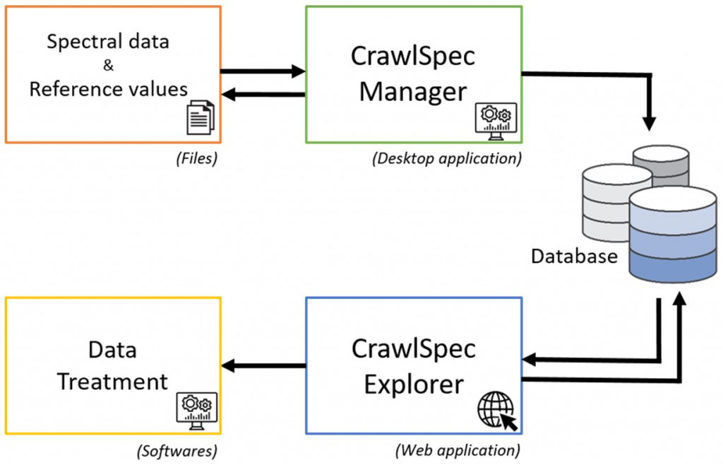
In this technological context, a second segment of the project, primarily involving CRA-W and UCLouvain, focuses on the development of two practical applications based on the analysis of data from these satellites. Scientific literature presents numerous proposals for hyperspectral imaging applications in the agriculture sector. Therefore, the goal is to assess their relevance with end users and determine the technical requirements (acquisition frequency and period, precision, spectral bands, signal-to-noise ratio, etc.). The expected outcome is an operational product tested in relevant environments.
In particular, CRA-W brings its strong expertise in trial management, variety evaluation, on-site analytical method development using optical sensors in the visible and near-infrared range, hyperspectral data processing, and analysis of aerial and satellite images. CRA-W is involved in coordinating measurement campaigns and developing applications related to the nitrogen status and health condition of wheat.
Due to its multidisciplinary nature and the partners involved, this project will also enable CRA-W to establish closer ties with private actors in the space industry. It will also provide an opportunity to showcase and strengthen its connections with stakeholders on the ground, particularly in the context of remote sensing utilization
Financing : SPW Economie, Emploi, Recherche - Skywin-Wagralim poles – Call 33, within the framework of the grant agreement 8614